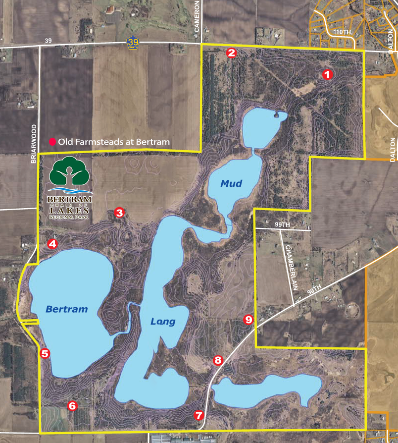
Farmstead #4 – YMCA Day Camp
This farmstead is probably the most familiar to people who have visited the park or were associated with the YMCA. The farmhouse was the last surviving remnant of the nine farms that existed on the Bertram property until is was torn down in 2018. This house was the home residence for several of the YMCA caretakers who took care of the property from the early 1960’s until 2012 when the property was sold to the county and the city. For a couple of years, this farmstead property was the temporary sight of the YMCA Day Camp until the YMCA built their new facility.
It has been hard to locate names of past residents of the property due to the fact that it lies on the edge of two sections, #17 and #16. The first names to appear were in 1859 to William Parvin & John Parvin, possibly brothers or father & son since William’s name appears first on the Warranty Deed. Another name was Arnold & Helen Fernberg, 1901-1950.
As you may recall from an earlier tidbit, this farmstead has some national notoriety. Some time in the 1990’s, the well-known author Clive Cussler wrote a book entitled “Valhala Rising” about the Vikings in North America. It’s more of an adventure novel but it does touch on the history of the Vikings and a “possible” adventure to Minnesota. In the novel he mentions finding a rune stone on the shores of Bertram Lake in Monticello, MN. He mentions the old barn as being the working office of a historical researcher and tells of the land gently sloping to the lake.
The new chalet is part of this property, as well as the machine shed and garage built by the YMCA. This garage was built for the mini bike program created for troubled youth.
Farmstead #3 – Worthington/William Kiebel
This farmstead out of all the other eight farmsteads is probably the best known for many reasons. The farm buildings themselves were located atop the rise 1/8 mile above Bertram Lake. The site of the building was just west and east of the road leading to the current turnaround. It was just west of the new YMCA Day Camp, and consisted of a house, large barn, hen house, two machine sheds, and a grainery. The house was surrounded by lilacs and locust trees which are still there today. Access to the farm was a long driveway north to County Road 39.
As with Farmsteads #1 and #2, the land was originally granted to John D. Taylor in June, 1957. The current parcel was deeded to Daniel Worthington in 1877, then to his son in 1889. In 1901 William Kiebel began purchasing the land including the parcel at the north end of Long Lake (NW corner Section 16 and SW corner Section 9). This is where the new Long Lake overlook is located.
I mentioned earlier that this farmstead is probably the best known of the nine sites because of the historical importance. Below are a few reasons:
- This property provided the easiest access to Long Lake during the winter months. It was Long Lake that provided the purest water and thus the purest ice for the ice boxes of Monticello residents. Ice blocks were cut for many years there.
- The beach on Bertram Lake provided the only access for many years for fishing, swimming, camping and picnicking. Many parties and reunions occurred under the oaks at the beach. Prior to the 1851 land purchase, the beach area at Bertram was a stopover spot for Native Americans traveling through the area.
- Currently, as in the past, the land by the beach provides a crossroads for the bike and hiking trails, as well as other activities throughout the park.
Farmstead #2 – Outhoudt Family
The land for their homestead was originally included with the land granted in 1857 to John Taylor. Some of the notable owners of this farmstead include:
- 1870-1900: E.J. Beedy Family
- 1910-1945: Marcus Wildman Family
- 1945-1963: Lehigh Cement Co.
- 1963-2010: YMCA
The last known name associated with the farmstead was the Robert (Bob) Outhoudt Family. They did not own the land but they lived on the property. It’s possible they did some farming, maybe dairy and other animals, but in general the land was not very suitable for crop farming. The land was located off County Road 39 to the north and continued south to Mud Lake. East of the property the land was wooded and to the west the land abutted prairie/crop land.
The property itself was hilly with glacial depressions, not suitable for farming, dropping to the south to Mud Lake.
In the 1960’s, the YMCA planted pine trees on the land for potential sale as Christmas Trees in the Twin Cities area.
Farmstead #1 – The Wildman’s
Minnesota became a state on May 1, 1858, but the distribution of land began after the Traverse des Sioux Treaty of 1851. To facilitate this, counties were established as the population grew. Wright county was formed in 1855, and much of the land began to be distributed and recorded. Since Monticello was selected to be the county seat, as the most populous city, the land around it began to be distributed early. The nearest property of the Bertram Lakes land was along County Road 39 in the NE corner, Section 9, of Monticello Township.
The very first name on the abstract to be listed as the owner of the land was John Taylor, dated June 23, 1857. I will try to present owners every 25 years to show transfers of the land to other owners:
- 1884-1895:King Staples (interesting name)
- 1895-1905: Charles Beedy (wife, Sadie) during this time Sadie became the sole owner of the land, which was a rarity!
- 1910-1946: Marcus Wildman & Family
- 1945: Lehigh Cement Co.
In 1945, the Lehigh Portland Cement Co. granted a right of way to Standard Oil Co. to lay, maintain, inspect, operate, replace, change, or remove a pipeline for the transportation of gas and oil.
The last listing in the abstract shows a date of October 17, 1963, at which time the YMCA of New Hope became the owners. The Lehigh Portland Cement Co. placed a stipulation on the land that it be used in its natural setting and at the time it fit the YMCA’s vision as a day camp.
The farmstead (house, barn, siloh, etc.) existed on the rise about 1,000 feet south of County Road 39. The foundation of the barn still exists today, just north of Otter Creek which flowed through the property. The creek was the farm’s source of water until a well was drilled later.