Bertram Chain of Lakes Glacial History
Within the last million years much of northern Midwestern USA was periodically covered by vast ice sheets (some 2.0 to 2.5 miles thick). Today, Minnesota’s surface features are mostly defined by the last (Wisconsin) glacial period which had four phases and ended some 10,000 years ago.
Formation and melt of such consecutive continental glaciers profoundly affected surface features of the land over which they moved. Vast quantities of rock and soil were scoured by ice from the original terrain and such abrasion redeposited as drift or till during glacial retreats. Till was dumped into preglacial river valleys while drift was carried further and heaped into hills (lateral or terminal moraines) at the margins of glacial lobes.
During meltdown, streams formed within ice sheets carried suspended material laterally (forming elongate eskers) or vertically (forming cone-like kames) which unlike moraine deposits contained few boulders. And outwash left by receding glaciers in central Minnesota was mainly of reddish sands or gravely shale (as is typical of much of the local Anoka Sand Plain). Depressions within these areas – in which ice chunks remained – became either fens or kettle lakes depending upon depth and how much water was finally retained.
Minnesota’s current preponderance of lakes represents a far different picture than in preglacial times when most of the land’s rain or melt water rapidly drained to the oceans of earlier eons. Today – precipitation retained at lake surfaces meanders through connecti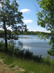 ng streams with only a portion of it finally reaching larger rivers and a long-distance run to the Gulf of Mexico.
Bertram Chain of Lakes is now characterized by four lakes – Bertram. Long, Mud and First (each with a maximum depth of 30 to 40 ft) – fed, interconnected, and drained to the Mississippi River by Otter Creek; a sizeable wetland area to the E (Beaver Pond); a unique fen remnant W of Bertram; a stream-bisected esker ridge between Bertram and Long, and a kame hillside E of Long adjacent to 90th Street. These geologic moments, along with a more recent history of nine demised farmsteads and remnant native versus invasive biota, make this future regional park a mecca of teachable moments for schools in the surrounding urban areas.
Martyn J. Dibben, Ph.D. Chair, Bertram Chain of Lakes Advisory Board