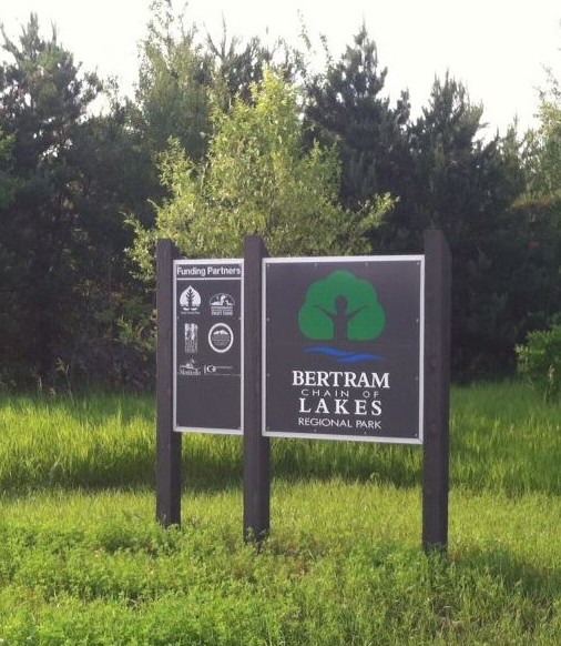
Camping at Bertram
Camping at Bertram Lakes has been happening for over 100 years. The post card a friend gave me (earlier tidbit) shows a girl fishing at
the Bertram Beach in 1906. At that time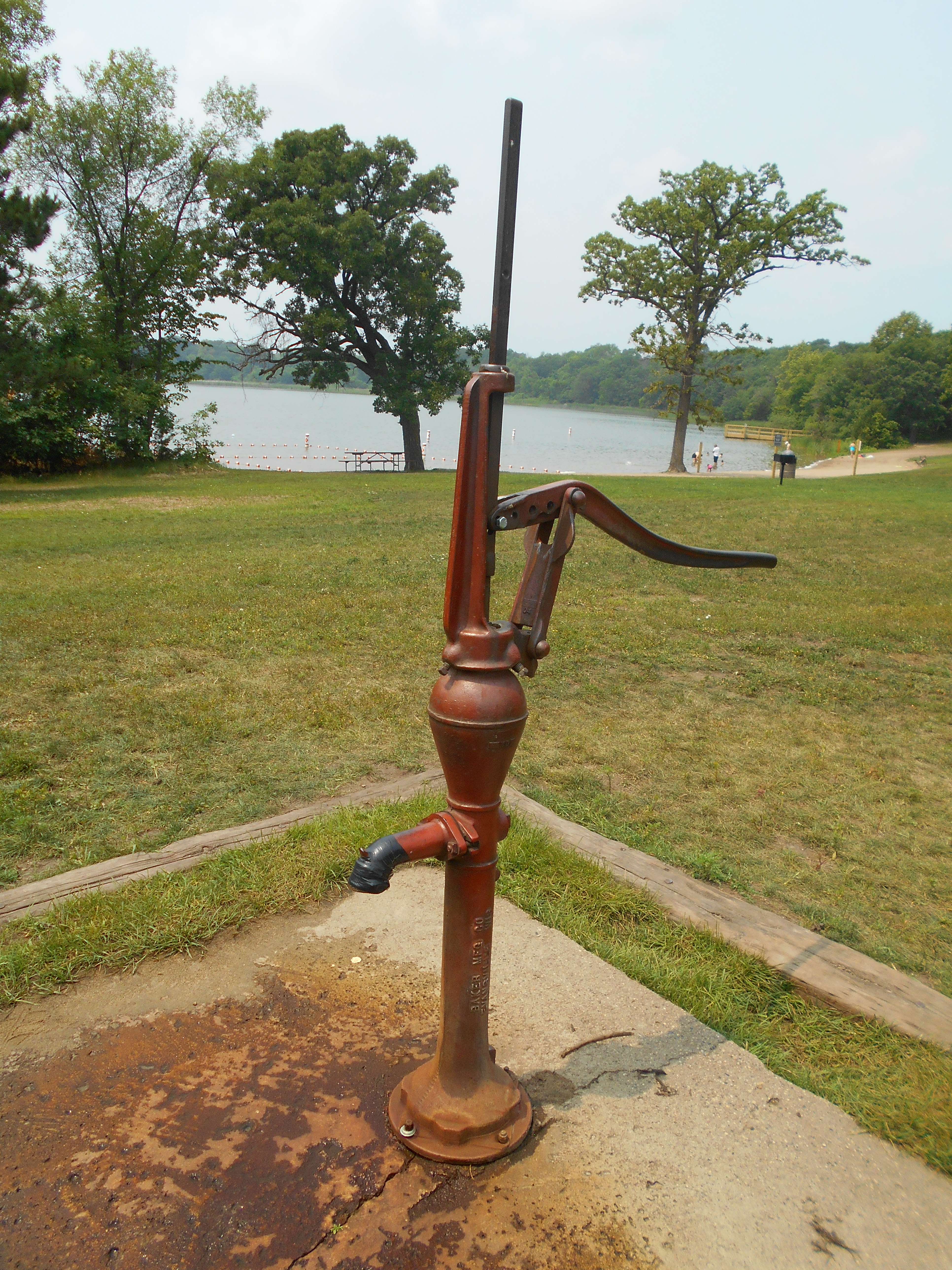 , the beach was accessible by road (driveway) directly connected to County Road 39, so camping may have been more prevalent then.
From the 1960’s thru the 1990’s, the YMCA maintained several sites for camping in the beach area, mostly during the summer months. These sites were located on both sides of the beach. To the southwest, along the northeast corner of Bertram Lake, there were five to six sites available. These were located within the oak and birch trees and were the choice sites. On the west side of the beach along the trail to the old chalet, there were four to five sites available, also within the oak trees. Camping during these times was primarily tent camping with only two pull-behind camper sites.
The only fresh water source for the campers was the pump located by the beach. For convenience, the YMCA installed two porta-toilets at the north side of the parking lot for the campers. At times, these served as changing places for families using the beach.
Native American Evidence at Bertram
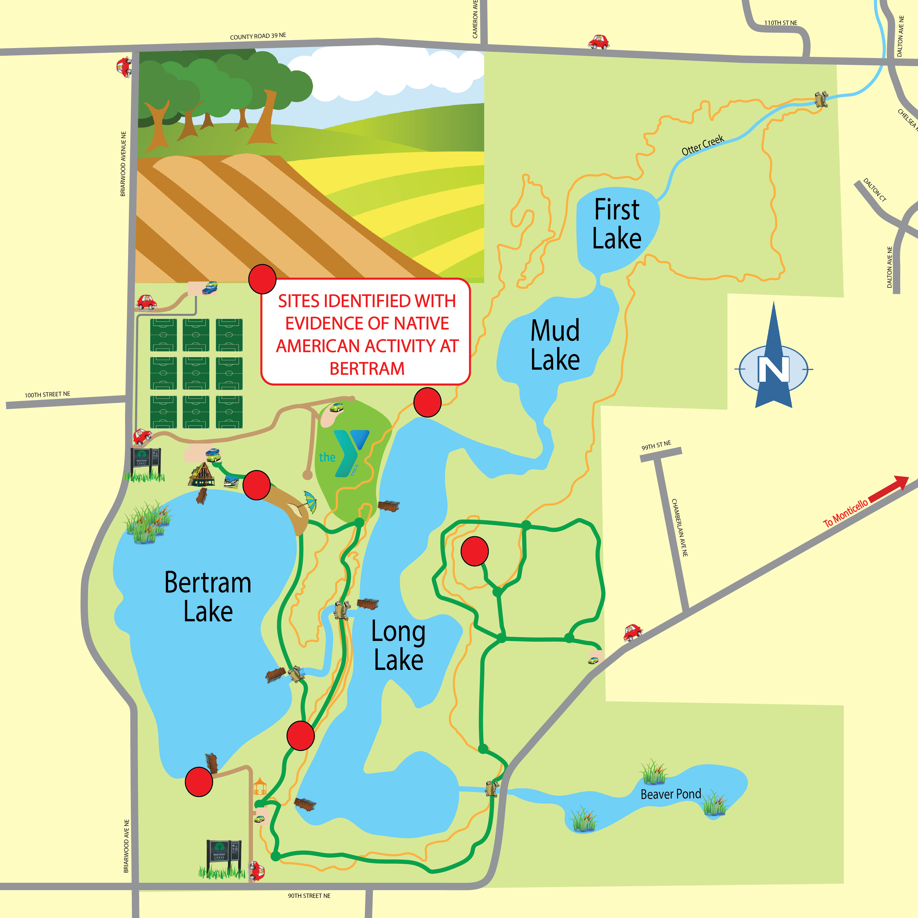
 Many people have asked me if there was any evidence of Native American activity around the Bertram Lakes area and I can say that there was. In 2009, when interest in purchasing the area from the YMCA became apparent, the Wright County Parks Department contacted Trefoil Cultural & Environmental Heritage Group to conduct a study of the Bertram Lakes Area. Five sites were located, which I will talk about later.
I must first mention a little background on the Native Americans who used the area and why. One group was the Eastern Chippewa. I say Eastern because they were originally from the upper New York and Canada region but were slowly pushed west as the European/American expansion happened. Most settled in northern Wisconsin, Minnesota and Canada but did range as far south into the area east and northeast of the Mississippi River. Being hunters and gatherers who traveled by river, they had some influence along the rivers.
The major group who left their imprint on the area were the Sioux, mostly an extension of the Plains Sioux tribes, primarily Santee. The Sioux tended to be nomadic and moved about the land in a more random fashion. The most common element between the two is that they camped in their movements within 200′ of a water source. Thus, when the study of the Bertram Lakes property was conducted, five sites were identified around Bertram Lake and Long Lake. The sites noted include:
- The north end of Long Lake
- The beach area at the north end of Bertram Lake
- The south end of Bertram Lake near the boat launch
- The open camping area southwest of the old YMCA Camp headquarters building
- The east side of Long Lake on the Kame
In studying the sites, the shovel and sifting method was used. Small pieces of quartz, chert and some remains of pottery were found. All areas had some remnants with the exception of the north end of Long Lake. None of the sites identified qualified for the National Registry.
The results of the survey seem to indicate that this was a “move through” area where natives stayed for a day or two and then moved on. Although, far from being proven, it seems that the Esker may be been the main avenue of travel for the native populations but this is only speculation.
Click the link here to view a map showing the sites with Native American evidence at Bertram.
Friends Launch New Membership Program
The Friends of Bertram is a volunteer group devoted to preserving and enhancing the experience of the Bertram Chain of Lakes Regional Park. Through various activities and efforts we seek to sustain the natural beauty and ecology of the park, support interpretive and environmental educational programs of the park, advocate for the park, promote awareness of the park’s resources, and provide volunteers and support when needed. We need your help. Become a Friend today!
The Friends launched a new member program effective July 1, 2017. Your annual membership dues of $20 will help to fund various projects and events at the park.
To learn more about becoming an official Friend of Bertram, please click here!
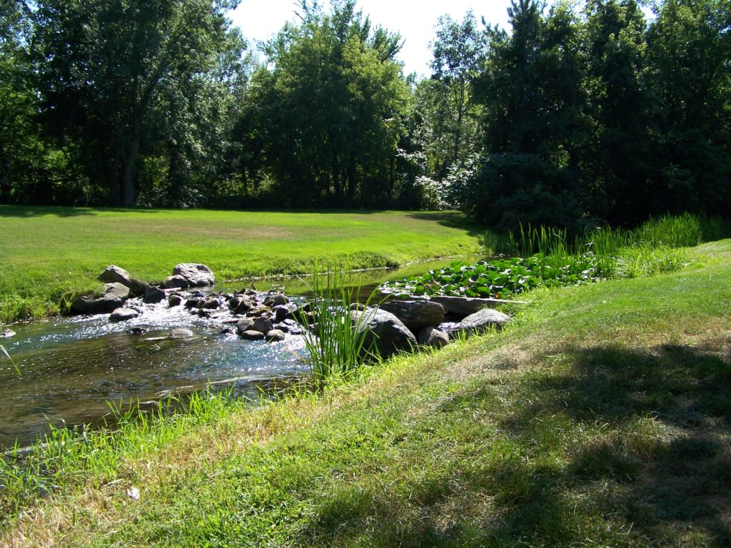
Otter Creek – The Life Line of the Park
 I find it hard to believe that I have not written about the importance of one of the most prominent aspects of the Bertram Chain of Lakes, Otter Creek. There are many details about the creek (probably even more than I know) so I will mention several.
First of all, Otter Creek begins in the southwest swamp area of Birch Lake. There may be other minor sources but it is hard to tell. It begins and passes through the land that in 1879 belonged to Juilia Bertram, wife of George Bertram. It should be noted that George Bertram died in 1879, leaving this land and several plots of land on West River Street to his wife.
Otter Creek enters Bertram Lake on the west side. In the spring, bow fishermen can be seen hunting suckers because this is a major area for spawning. I hope that is all they hunt. The dam is located where Otter Creek exits Bertram Lake. It was placed there to control the water level of the lake and has done so for almost 100 years (since 1922).
Since the parkland falls in the center of a glaciated area, there are many springs that feed Otter Creek. Between the dam and Long Lake, there are a few minor springs but south of where the creek enters Long Lake, there is an underwater artesian well. If you are ever canoeing or kayaking on Long Lake, feel the water in the middle of the lake and then paddle to south end and feel the water again, you will find a noticeable difference in the temperature between the two.
After Otter Creek exits Long Lake, it flows through Mud and First Lakes. On the north side of these lakes the Portland Cement Company had a processing plant for marl, which is the main ingredient for cement. Over the centuries the fine textured marl would wash off the land and settle in the bottom of the lakes. Portland Cement Co. mined the bottom and eventually enlarged the lakes. Otter Creek then was allowed to flow through them and clean much of the debris.
From First Lake, the creek flows to the Mississippi River passing under County Road 39, under Interstate 94, through the golf course, through Otter Creek Park, under County Road 75, and finally down to the Mississippi River. To my knowledge, Otter Creek has never been dry. Due to the many springs and the Artesian well, it is constantly flowing and because of this, the creek is day after day, year after year, mixing with the waters of the lakes and keeping them clean. This is a wonderful resource and we need to protect it as long as we can.
Briarwood Avenue
Briarwood Avenue is the main road along the western edge of the new Bertram Chain of Lakes Regional Park. It will eventually be the major access to the Park, as well as the Athletic Complex. But, Briarwood Avenue did not always run along the edge of Bertram Lake. according to county plat maps, in 1879, the original road came south from County Road 39 but turned at 100th Street and continued west, over the hill and through the woods along the south side of Birch Lake.
Also, in earlier times (1850’s & 1860’s) at the corner of 100th and Briarwood, a wagon trail went south around the west side of Bertram Lake and behind the later built Keibel farm. It continued around the south sides of both Bertram and Long Lakes, and into Monticello. 90th Street would later be built over the Monticello part until it connected with Cahill Avenue. The part of Briarwood from 100th would later be connected around Bertram to 90th Street.
On a side note, when the road continued west along the south side of Birch Lake, it went through property owned by none other than Julia Bertram, George Bertram’s wife.
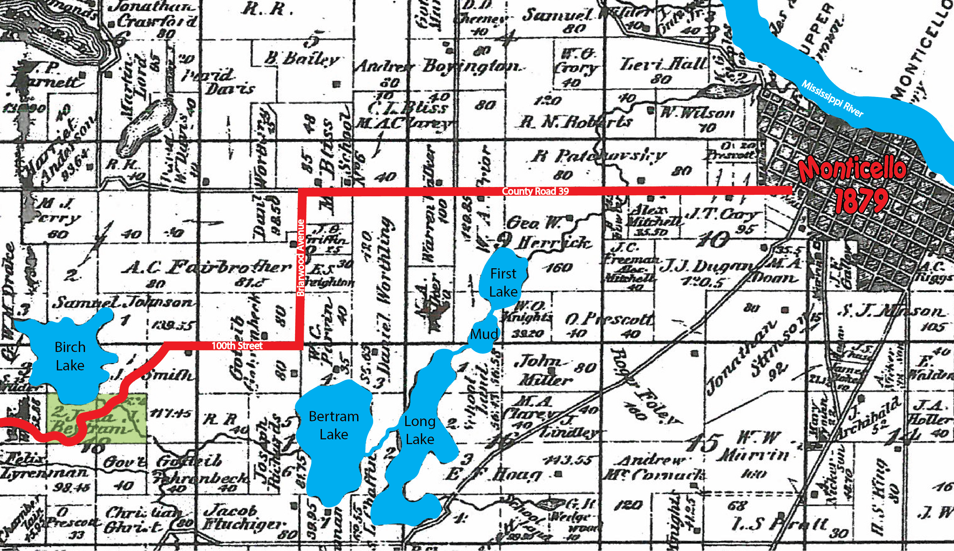
1879 Plat Map of Monticello Township
Bertram Lakes Cabins
 There have always been questions as to the existence of cabins on the property, especially near Bertram Lake.
In 1901, a man named Daniel Worthling owned lot #4 of section 9 and lot #3 of section 17 in Monticello Township. These lots included the land from the Bertram Lake Beach north to County Road 39. By 1915, these same plots of land were owned by William Kiebel who built a farmstead just west of the new YMCA Camp.
Between the dates of 1901-1910, this postcard was sent to Newton, Iowa. It is dated September 1, 1906, and it is noted on the card, “This is where your SS (social studies) teacher is spending her vacation.” In the photograph, a girl is fishing with a cane pole sitting on what appears to be a slab of cement. In the background there are two women, a young child and a tent. The location is at Bertram Beach with the oak trees. In the upper right of the photo is the gap in the trees where the access road enters.
Camping, it appears, has at least been happening since the early 1900’s, and continued into the early 1990’s. As for cabins, very little is known and it has been speculated about over the years. Rumor has it that at least three cabins were located west of the beach alongside of the trail leading to the new chalet building. One site may have been located right under the current path from the parking lot.
Continued research is needed, but it is known that the area at and near the beach has been enjoyed by many generations of nature lovers!

